

This article was automatically translated from HIBAPRESS, the Arabic version:
HIBAPRESS-RABAT-MAPDD
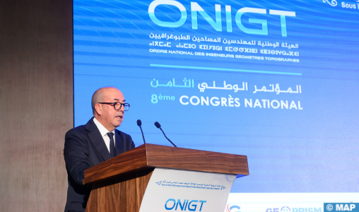
Intervening at the opening of the 8th National Congress of the National Order of Engineers Surials Great Topographers (Onigt), which is placed under the high patronage of SM King Mohammed VI, Mr. El Bouari, the Minister of Agriculture, Maritime Fisheries, Rural Development and Water and Forests, highlighted the role of geomatics in the sustainable management of natural resources and the integration of cutting-edge technologies artificial (AI) and remote sensing, knowing that geomatics has become a strategic lever for land security, food sovereignty and territorial planning
And to continue: “This is why I want to reaffirm our desire to further consolidate our collaboration with Onigt, in the continuity of actions already undertaken within our ministry for the implementation of strategic projects at national and continental level”.
Mr. El Bouari noted that the theme chosen for this 8th congress, “Morocco of initiatives for an emerging Africa”, resonates deeply with the commitment of the Kingdom for a united, integrated and prosperous Africa, and underlines the strategic contribution of the geomatic profession at the service of continental development.
The contribution of geomatics to the agricultural sector is undeniable, argued the minister, explaining that the transformation of the agricultural sector is based on a secure land basis, well -planned infrastructure, intelligent management of natural resources and transparent territorial governance. According to him, all these dimensions require a sharp geospatial expertise, integrated and in accordance with international standards.
To this end, Mr. El Bouari recalled that the ministry, which considers ONIGT and the profession as strategic partners, has embarked on structuring sites whose success depends directly on the intervention of topographer geometers engineers.
He also indicated that intelligent agriculture, envisaged within the framework of the strategy “Generation Green 2020–2030”, cannot be deployed without precise, dynamic and accessible land information, adding that each geographical data becomes a lever for action which implies the implementation of robust geographic information systems, coherent data platforms and close collaboration between public actors and geomem experts.
“We need precise cards to identify the vocations of the soils, topographic models to plan irrigated perimeters, space readings to follow the evolution of crops, cadastral data to secure the rights of use, and geolocating to optimize the distribution chains,” he detailed.
The opening ceremony was marked by the signing of a memorandum of understanding between the representatives of the orders of the present African countries, namely Morocco, Benin, Burkina Faso, Cameroon, the Democratic Republic of Congo, Côte d’Ivoire, Mali, Niger, Senegal, as well as Togo.
As a prelude to this opening, the “Surveying African Conference” was held, with the participation of 11 African delegations. Initiated by Onigt under the theme “Cooperation and partnership for an emerging Africa”, this first edition set the milestones of shared land governance, by valuing national complementarities and by transferring technologies adapted to local realities.
The feedback from Senegal, Côte d’Ivoire and Morocco have demonstrated how modernized cadastral management contributes to social stability and attracts investments.
On the program of this 8th two -day ONIGT congress, three panels are “securing land in the service of agriculture in Africa”, “territorial planning and land governance” and “major structuring projects within the framework of southern – South cooperation”.
Transversal profession, topographic engineering covers mapping, geodesy, agricultural consolidation, urban subdivision, condominium, land delimitation, regional planning and construction.
In 2024, the 1,239 ONIGT members (including 702 in the private sector) and its 700 partner companies generated more than 15,000 direct jobs, 30,000 indirect jobs, a turnover of 3 billion dirhams and annual investments over 100 million dirhams.
The profession thus contributes to the success of major sites (LGV, renewable energy parks, ports, highways, generation Green, new cities and stage and infrastructures of the 2030 World Cup).